Nobody hands you a map at Actun Tunichil Muknal. There is no visitor centre, no orientation film, no laminated card with a red dot telling you where you stand. You get a helmet, a life vest, a headlamp and a guide who has walked the same passage several hundred times. That is the entire navigation system.
Which suits the place, honestly. ATM (everyone says the letters, never the cash machine) is one linear river passage bored through Cretaceous limestone, and you either walk up it or you don’t. There are no junctions to get lost in, no side galleries to wander off into, and no souvenir stall at the end.
I have been through six times now, notebook in a dry bag, and I still flinch at the same cold shock when the water reaches my ribs. What follows is the walkthrough I wish someone had given me before my first attempt: what the ATM Cave entrance actually looks like from the pool, how the route unfolds stage by stage, and the honest truth about ATM Cave pictures.

The Route at a Glance (and Why There Is No Visitor Map)
There is no printed ATM Cave map, and that is deliberate rather than lazy. The reserve has no gate signage worth the name, no interpretive boards, no numbered trail posts. What exists instead is a surveyed length: 3.13 miles (4.8 km) of mapped passage, of which visitors walk roughly one kilometre upstream to the dry galleries, then retrace every step.
So the “map” is really a sequence. Six stages, always in the same order, always with a licensed guide at the front and another at the back of a group no larger than six. Right then, here is how the morning actually runs.
- Trailhead at Tapir Mountain Nature Reserve: parking, changing rooms, helmet and life-vest fitting, waiver signature.
- Jungle approach: a flat 2-mile (3.2 km) rainforest trail with three wades across Roaring Creek.
- Entrance pool: a 20-foot (6 m) swim through spring-fed water into the cave mouth.
- Wet corridor: 60 to 90 minutes of upstream wading over breakdown boulders, with one subterranean waterfall step.
- The ladder and dry galleries: shoes off, socks on, then the stelae chamber, the Cathedral and the Crystal Maiden’s alcove.
- Exit: downstream, faster than you’d think, plus the optional neck-deep squeeze or its bypass.
| Stage | Typical duration | What actually happens |
|---|---|---|
| Trailhead fitting | 20–30 minutes | Helmets, lamps and vests issued; liability release signed; last proper flush toilet of the day |
| Jungle trail | 45 minutes | Flat forest walking, three river crossings, boots wet by minute fifteen |
| Entrance pool | 5–10 minutes | Life vest check, then a short swim into the dark |
| Wet corridor | 60–90 minutes | Ankle-to-chest wading against current, boulder scrambles, headlamp-only visibility |
| Dry galleries | 60–75 minutes | Socks on, single-file on red tape, stelae, Cathedral, Crystal Maiden |
| Return | 45–60 minutes | Downstream with the current, then the trail back out to lunch |
One detail worth knowing before you plan anything: the entire daily quota enters in a single morning wave, because there are no afternoon departures at all. That is why the three internal choke points (the ladder, the Crystal Maiden alcove, and the exit squeeze) develop queues between roughly 10:15 and midday. Groups that start early get an empty cave. Groups that don’t get a very sociable one.
Stage One: The Trailhead at Tapir Mountain
The last outpost of civilisation is a gravel parking lot at the end of a 7-mile unpaved road from Teakettle Village, and it is a better facility than the approach suggests. Restrooms, changing rooms, picnic tables under shade, and a fitting station where your helmet gets sized and your life vest gets clipped.
Parking is free for authorised tour vehicles, which is a small mercy given the state of the road. If you are self-driving to meet an operator, the Belize Audubon Society, which co-manages the reserve, is the body to check for access notes; the site itself is administered by the Institute of Archaeology under NICH Belize.
Three practical things happen here, in this order. You sign the liability release (more on that over on the safety page). You empty your hands completely, because nothing goes into the cave except what your guide carries in a waterproof dry bag. And you use the loo, because there are no restrooms and no bins on the trail or inside the cave.
If you are staying nearby, Pook’s Hill Lodge in Teakettle Village sits about a two-minute walk from the reserve boundary, which turns a 5:30 AM highway run into a lie-in. See Pook’s Hill Lodge for rates.
Stage Two: The 45-Minute Jungle Approach
Two miles of flat rainforest trail. Forty-five minutes at an unhurried pace. That’s the whole physical brief, and it fools people every time, because the walking is easy and the wading is not.
Roaring Creek is crossed three times. Usually the water sits somewhere between knee and waist height. In flood conditions it can climb to your neck, and the Institute of Archaeology has cancelled whole days when it does. Keep an eye on Belize Tourism Board channels and your operator’s messages if the rain has been biblical.
The forest itself is the underrated half of the day. More than 340 bird species have been recorded in this corridor, and the howler monkeys generally announce themselves before you see them, sounding like a diesel engine with a grudge. Humidity sits somewhere near “sauna”. You will be sweating before you are wet, then wet before you are underground.
Which brings up footwear. Closed-toe shoes with real tread are mandatory: trail runners, hiking shoes, proper water shoes with a sole. Flip-flops and thin sock-style swimmers get turned back, and the full dress code lives on the visitor rules page. Here is the bit nobody internalises: you start wet long before you start caving. Soggy boots are the baseline, not the emergency.
Stage Three: The Entrance Pool and the Cave Mouth
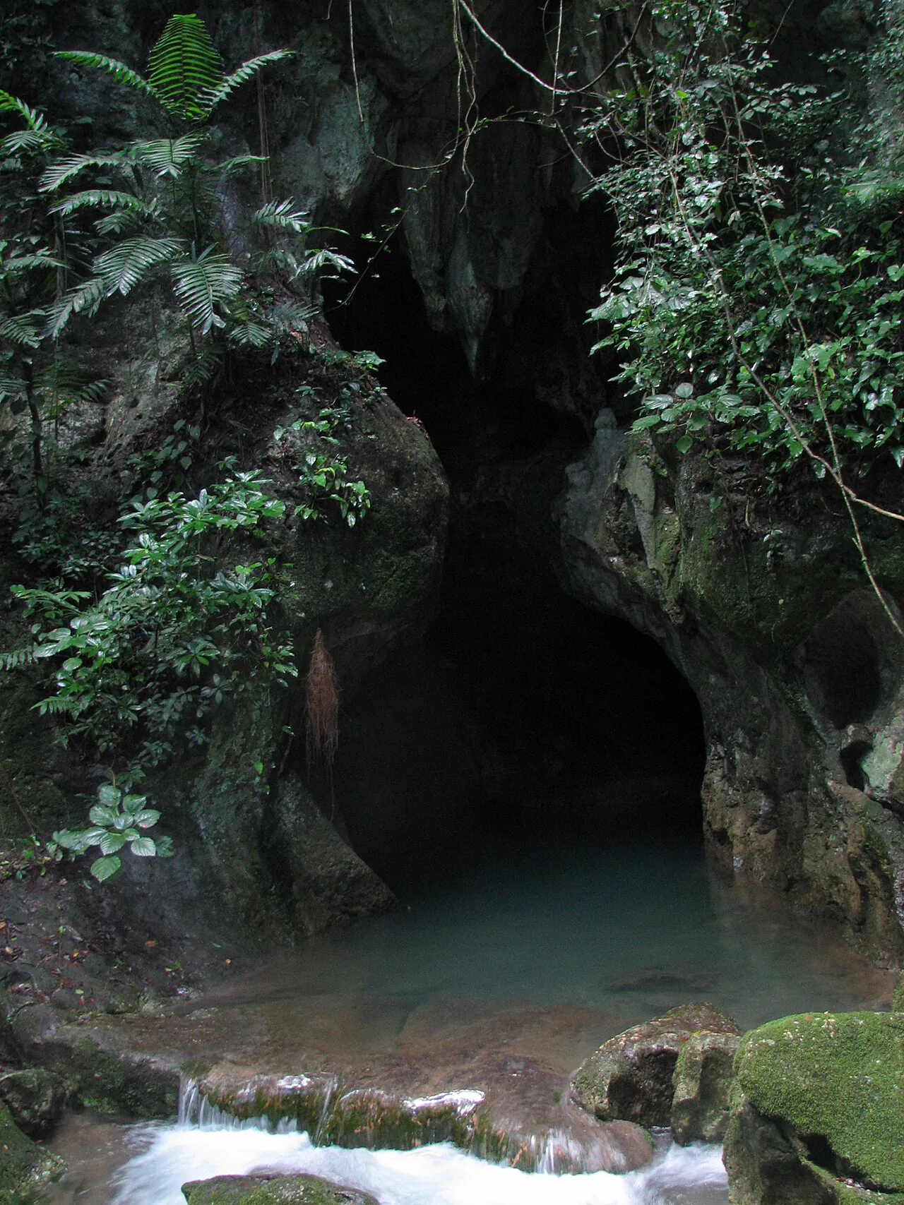
And then the trees open, and there it is. A spring-fed pool the colour of weak tea, a vine-draped rock mouth above it, and a 20-foot swim between you and everything else. The water holds a constant 25°C (78°F) year round, which is lovely in theory and briefly shocking in practice.
Life vests are compulsory. Non-swimmers get floated across by the guide, one hand on the vest, no drama, no audience. I have watched a genuinely nervous 70-year-old go across on her back grinning like a child, so “I can’t really swim” is not the disqualifier people assume.
The register changes at this pool. Outside there are birds and light and the smell of leaf litter; five strokes later there is a black wall, a helmet lamp, and the sound of your own breathing. I always think of the Maya choice to walk into this, with torches, carrying pottery, for reasons that were not recreational.
The cave mouth is where the trip stops being a hike and starts being an act of nerve.
Stage Four: The Wet Corridor, 90 Minutes of Upstream Work
Inside, you wade. Ankle-deep, then knee, then chest, then ankle again, always against the current. Breakdown boulders the size of fridges have to be climbed over or slid around. There is one step where a subterranean waterfall drops onto your shoulders, and several places where you tilt your helmet sideways and trust the guide’s hand.
The geology explains the whole shape of the place. Cretaceous limestone, dissolved by running water over an absurd stretch of time, has been sculpted into a river passage with stalactites overhead and flowstone curtains down the walls. Light comes from headlamps only. There is no ambient light whatsoever, no green glow, no emergency strip lighting. Switch every lamp off for ten seconds and the dark is genuinely absolute.
The Neck-Deep Squeeze (and the Bypass Nobody Mentions)
On the way out there is an optional squeeze, affectionately known as the decapitation path, where your shoulders go under and your head turns sideways to clear the rock. It is short. It is also entirely avoidable.
A wide-open bypass runs right beside it, and hardly anyone mentions that to nervous first-timers. If you would rather not, say so to your guide at the trailhead rather than at the rock. Nobody minds. Doing it in cool water with a queue behind you is a far worse place to discover a preference.
Stage Five: The Ladder, the Socks and the Dry Chambers
The transition is abrupt. One moment you are hauling yourself up a wet metal ladder of 12 to 13 feet (about 4 m), the next you are standing on dry, calcified floor in damp socks while your shoes stay in a heap below. Guides call the ladder “the elevator”. It is the single biggest queue point in the cave, and the moment the day changes tone.
Socks are non-negotiable up here, and not for comfort. Bare feet and wet shoes grind the calcite floor into paste and damage a surface that took millennia to form. The route through the dry galleries is marked with red tape and walked single file, and you stay on it.
This is where you stop being an adventurer and start being a visitor in somebody’s ceremonial space. Helmets stay on, voices drop, and the group naturally strings out into a quiet line.
The Stelae Chamber and the Monkey Pot
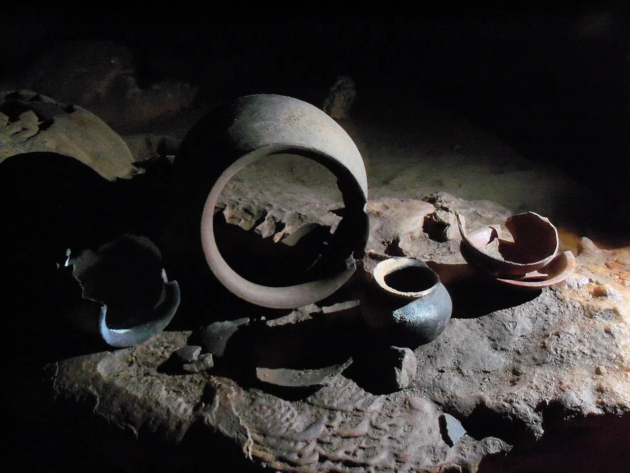
The first dry gallery holds carved slate stelae standing upright on the floor, obsidian blades laid out as they were left, and a vessel with a monkey motif that guides always point out first. Bloodletting artefacts sit in the same frame of view. It is a lot to take in while standing in socks.
I will keep the interpretation short here on purpose. What you see is the surface of the story; the ritual meaning, the dates, the argument about what was offered and to whom, belongs on the Maya history and Crystal Maiden page. This page is about the physical walk, and the walk has only just reached the good part.
The Cathedral: 1,400 Pots and 14 People
Nothing prepares you for the scale of the main chamber. Somewhere between 200 and 350 metres long, roughly 50 metres wide, and filled with more than 1,400 ritually “killed” ceramic vessels, grinding stones, flowstone altars and 14 calcified skeletons. No ropes. No glass cases. No barriers between your socks and a thousand years of somebody’s most serious business.
The acoustics are the thing my notebook keeps returning to. Sound dies fast in here. A group twenty metres away sounds like a group in another building, and your own voice comes back flat and small. There is a mineral smell, wet stone and old dust, that I can summon from memory on a hot afternoon in town.
Compare it, if you like, to a country church with the roof still on: same hush, same instinct to lower your voice, none of the same certainties about what people were praying for.
What the Crystal Maiden Area Actually Feels Like
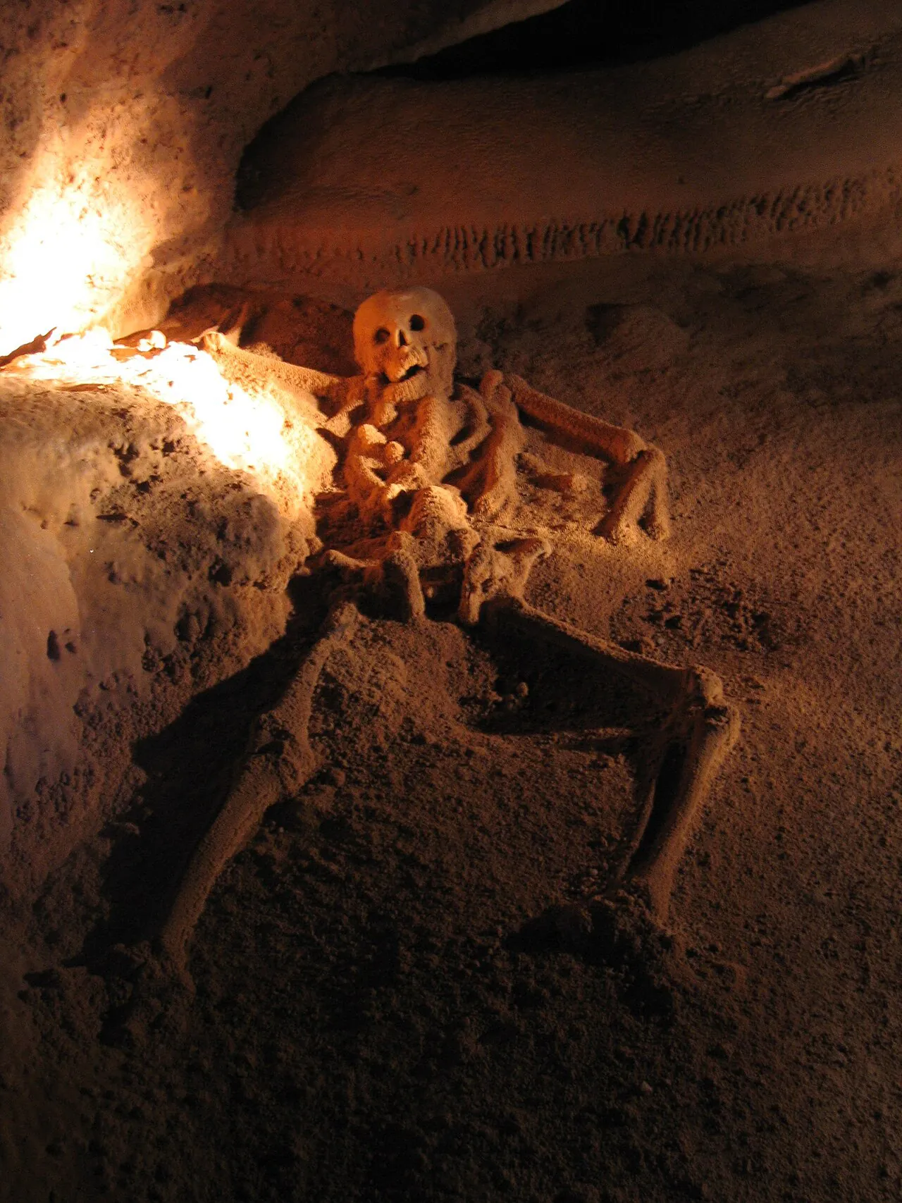
The route ends in a small terminal alcove, up a short climb, where calcite has grown over a skeleton until the whole surface glitters under a headlamp. That is the Crystal Maiden, and the sparkle is not a camera trick. It is mineral, and it is genuinely startling in a place this dark.
Researchers still disagree about the individual’s sex and age, which is why guide accounts vary so much between operators. One will say a young woman, another a young man, another will carefully say “we don’t know”. All three are being honest.
The alcove holds perhaps eight people comfortably, so groups take turns, kneeling or standing in a loose arc while the lamp beam picks out detail. Everyone goes quiet. Not reverent-performance quiet, actual quiet. Then you shuffle back down and let the next group in.
Photos: What You Can and Cannot Take
Here is the hard rule: all cameras, phones, GoPros, drones and smartwatches are banned inside the cave by government regulation and stay locked in the vehicle. Not “keep it in your pocket and be subtle”. Banned. Your ATM Cave pictures will be taken at the trailhead, on the jungle trail and at the entrance pool, and that is the lot.
The reason is conservation, not officiousness. Camera flashes and dropped equipment damage a closed, humid environment where calcite grows at a geological crawl, and every visitor who crouches for a low angle risks a boot on an artefact. Six people per guide, one file, red tape: the whole system exists to keep feet off the archaeology.
So where do the images you have seen online come from? A small number of permitted and archival shoots, plus the era before the ban. National Geographic coverage of the site and its ritual deposits did a great deal to put Actun Tunichil Muknal on the map, and most of the striking ATM Cave Belize pictures circulating today trace back to that kind of access.
- Allowed: trailhead, jungle trail, river crossings, the entrance pool, lunch at the picnic tables.
- Allowed: a waterproof phone in a dry bag, used only before the swim and after the exit.
- Not allowed: anything electronic past the cave mouth, including action cameras mounted on helmets.
- Not allowed: tripods, selfie sticks, drones, or a “quick flash” for the Crystal Maiden.
Some operators sell or share guide-shot images afterwards, which is the practical workaround. Ask before you book rather than on the drive home.
Walking Back Out
The return leg is faster, because the current is doing the work. The squeeze or its bypass comes up, the water gets shallower, and then you are blinking in daylight at a pool that suddenly looks smaller than it did three hours ago.
Lunch at the picnic tables is a proper Belizean affair: rice and beans, stewed chicken, and a queue for the changing rooms. Bring a dry bag for the wet kit and a spare pair of socks for the drive, because the ones you wore through the dry chambers will be grim.
If you are still deciding which operator to go with, or whether to start from San Ignacio or Belize City, the tickets and tours page lays out the bookable options side by side. For the walk itself, all you really need to remember is this: the ATM Cave entrance is a short swim, the route is one line upstream, and the photos will be in your head whether or not they are on your phone.
Still weighing up the practical side? Read the visitor rules for footwear and the camera ban, the difficulty and swimming guide before you commit, and the transport page for how the morning actually starts.